U.S. Drought Monitor
Our primary focus on drought relates to drought impacts on water supply, including all of the drainages basins in Colorado. Currently, drought awareness is most acute in the Colorado River Basin. The term drought is used almost like art; it means different things to different people. As scientists and engineers, we measure rainfall, temperature, river flows and wind to place a numerical value on drought for management purposes (see LWS blog series on CO Water Law Basics #14.1, #14.2, #14.3), but the meaning of drought is mostly subjective. This blog is an introduction to the data compiled by the National Drought Mitigation Center (NDMC) at the University of Nebraska-Lincoln and the varied conditions that are lumped into the term “drought”. The NDMC is funded by the U.S. Government (U.S. Departments of Agriculture, and Commerce, and the National Oceanic and Atmospheric Administration).
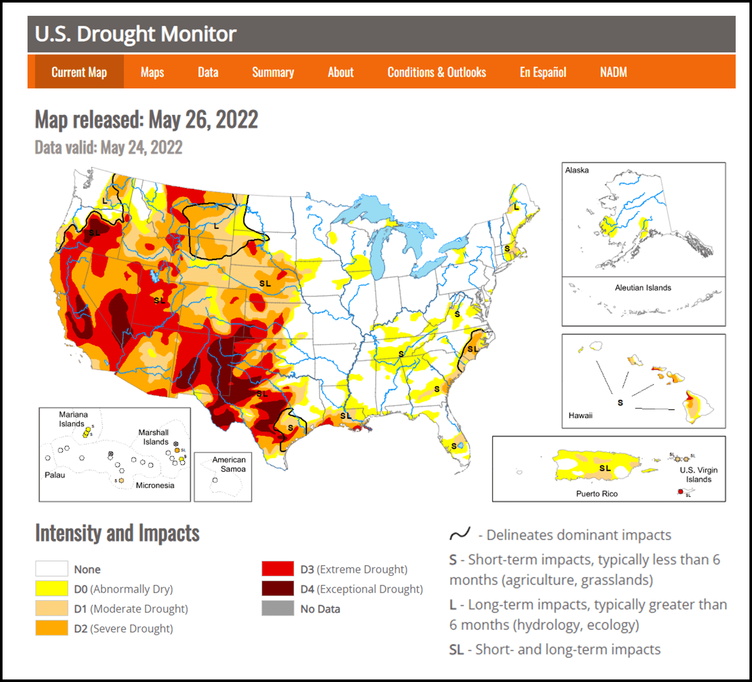
Figure 1: Drought Monitor Map released May 26, 2022.
The NDMC runs a website where their data are available to all (https://droughtmonitor.unl.edu/) and can be accessed in the form of tables, graphs, and maps. The maps are updated each Tuesday at 8 a.m. The main page (Figure 1) is a map showing areas shaded by categories of Intensity and Impacts. A glance at this main page draws the eye to dark red areas of exceptional drought. Further perusal reveals that there are five subjective categories of drought including: D0 (abnormally dry), D1 (moderate), D2 (severe), D3 (extreme), and D4 (exceptional). However, these categories are not equivalent everywhere and do not relate to a particular amount of precipitation or lack thereof. They are based on the effects caused by dryness.
An example of these effects and their differences by region can be seen in a comparison of the descriptions of Intensity and Impacts for Colorado and New Mexico (Table 1 from https://droughtmonitor.unl.edu/DmData/StateImpacts.aspx). The conditions attributed to each state are “historically observed impacts,” which are subjective, but very visceral descriptions of what drought really is.

Table 1: Comparison of the descriptions of Intensity and Impacts for Colorado and New Mexico.
Obviously, New Mexico has a dryer climate than Colorado, but what is striking is that in these two adjacent states, the same categories of drought are experienced, felt, or noticed somewhat differently. Dissimilarities between Colorado and Maine are much more obvious. For example, fish kills occur in Maine’s D2 compared with Colorado’s D3.
When the water resources in Colorado are stretched by the expansion of cities on the Front Range, additional drought effects could possibly be added to the impacts list, such as water sanitation concerns and water shortages like those already included in California categories D3 and D4.
Prudent water supply development and management of these precious water resources has always been at the core of LWS’ approach to efficiently provide needed water supplies. For more information on careful water resources management please see the LWS blog series on “Integrated and Sustainable Water Management Plan for a Growing City - A case Study” (Part 1, Part 2, Part 3).
If you have any water resources issues, LWS can help; please contact us for help at 303-350-4090 or by email.
Bruce Lytle, P.E.: bruce@lytlewater.com
Anna Elgqvist, EI: anna@lytlewater.com
Maura Metheny, Ph.D., P.G.: maura@lytlewater.com